
Panama declared a nationwide state of emergency after twin earthquakes, including a magnitude 7.7, caused major shaking, damage, and evacuations.
Story Highlights
- Two powerful earthquakes, magnitude 7.7 and 6.6, struck Panama hours apart.
- Officials reported toppled buildings, hundreds of damaged structures, and at least 27 minor injuries.
- Presidential Minister Juan Carlos Orillac announced a state of emergency to coordinate relief.
- Aftershocks continued as authorities focused on search, safety checks, and aid delivery.
What Happened and Where It Hit
United States Geological Survey (USGS) data show a magnitude-7.7 earthquake struck near Pitaloza Arriba at 12:56 p.m. local time on October 9, 2026. A second magnitude-6.6 quake hit near Río Grande at about 3:25 p.m. local time. The USGS assigned very strong-to-severe shaking levels to these events, which matches reports of structural damage and evacuations in affected towns. Some outlets described the second quake as an aftershock, though seismologists will refine the sequence over time.
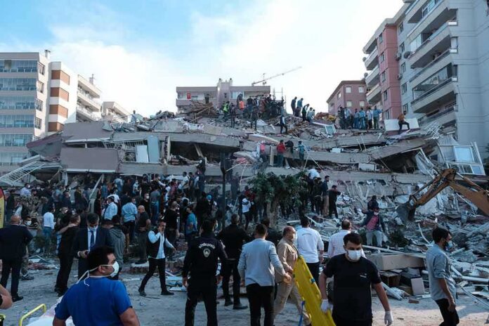
Local news and international outlets reported toppled buildings near the epicenter, damage to homes and offices, and streets littered with debris. BBC Mundo reported at least 27 minor injuries and damage to hundreds of buildings, including businesses and government facilities. Evacuations took place across parts of the Azuero Peninsula and beyond as people felt strong shaking and continued aftershocks. Officials warned residents to stay clear of damaged structures until engineers complete safety checks.
Emergency Declaration and Government Response
Presidential Minister Juan Carlos Orillac announced a state of emergency on October 10 in Panama City. The declaration aimed to speed coordination, move resources, and support impacted communities as aftershocks continued. Authorities prioritized life safety, medical care for the injured, search of damaged areas, and restoring key services. Reports described civil defense teams, police, and local officials working together on evacuations, inspections, and aid distribution.
Emergency managers said the order would help cut red tape for supplies, temporary shelters, and contracting. That step often allows agencies to buy equipment faster, surge staff, and access special funds. While detailed legal terms of the decree were not immediately available, news reports linked the measure to relief logistics and interagency coordination. Officials also urged the public to follow guidance and rely on trusted alerts as the ground kept shaking.
Why the Quakes Packed Such a Punch
Earthquakes of magnitude 7.7 and 6.6 release large energy and can cause severe shaking close to the epicenter. The USGS explains that intensity, not just magnitude, drives damage on the ground. Building type, soil conditions, and distance all matter. Reports of collapsed walls and cracked roads near the Azuero Peninsula are consistent with high-intensity shaking. As with many major quakes, agencies may revise magnitude estimates as they process more seismic data, which can explain small number differences across outlets.
Residents across the region faced a common set of risks after the main shocks: weakened buildings, landslides, and falling debris. Authorities typically restrict access to damaged zones until structural teams clear them. Hospitals and clinics often see a wave of injuries from cuts, falls, and struck-by incidents. Keeping communications clear and accurate becomes vital, especially when aftershocks keep people on edge and rumors can spread. Emergency guidance stresses verified updates and simple safety steps.
What This Means Beyond Panama
For the United States and the region, the quakes highlight a recurring test: can governments act fast, cut waste, and still protect people? Disasters do not care about politics or borders. Strong coordination saves lives and money when time is short and needs are sharp. The United States Geological Survey’s global networks and tools support rapid detection and mapping, which can help planners and aid groups target help where it is needed most.
What to Watch Next
Authorities will update damage counts as inspections finish and communities report losses. Teams will assess roads, bridges, water lines, and power systems. Engineers will tag buildings as safe, limited, or unsafe. The government may issue more guidance on funding, aid rules, and timelines. People in the affected area should expect aftershocks for days or weeks. Staying alert to official messages and avoiding damaged structures remain the most important steps.
Sources:
youtube.com, ajc.com, globalnation.inquirer.net, usgs.gov, bbc.com, english.news.cn
© patriotwise.com 2026. All rights reserved.